


Yesterday I took a drive out toward the southern tip of the Kalmiopsis Wilderness. From Brookings, I headed out Winchuck River Rd for about 10 miles. After the pavement ended I drove another 45 minutes to get to the head of the Sourdough Trail. Well, actually, the road became too overgrown to get through the last mile with my truck so I parked and hiked up to the trail head.
What an interesting trail. I hiked through a low-shrub (manzanita?) section on a ridge with a view of the ocean and one lone bear grass bloom. More dense forest followed - myrtlewood, blooming rhododendron, fern, salal, and some Douglas fir. Then, a weathered wooden sign tacked to a tree said "Winton Prairie" and I was suddenly in a meadow. To my right, I spotted a pile of rocks supporting a vertical post. The sign had long since fallen, but was still legible: Al Hanziker, Miner / Born 1870 Died 19?? / Froze to ???? Here.
Thankful it was hot and sunny, I hiked onward through the meadow which promptly transitioned to...Ponderosa Pine? What? I blinked a few times to assure myself I really was seeing Ponderosas. Convinced, I hiked onward, then the Ponderosa forest ended almost as abruptly as it began. The pines shrank and thinned, revealing a panoramic view of the distant wilderness. There was no doubt about the reaches of last year's Chetco Bar fire; twisted, blackened skeletons stretched across hillsides and a large landslide was evident. From a distance it appears dead, but new life is beginning as it always does after a forest fire.
The terrain here was more dry and rocky, but surprisingly full of color with blooming Indian paintbrush, Bolander's Lily, aster, yarrow, fragrant Western azalea, and a purple composite flower resembling allium (which I later identified as coyote mint). Admittedly, half my reason for this outing was to photograph Bolander's Lily in bloom, so I was content; but to also witness this incredible display of diversity in about one mile, well, I was ecstatic! I checked my map and began to understand why this is the Lemmingsworth Gulch Research Natural Area. 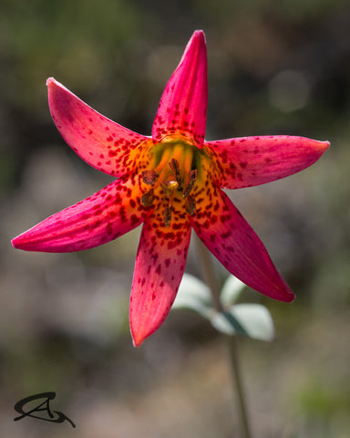
Despite getting low on water, I pressed on, determined to get to the North Fork Smith River. The dry, rocky trail descended steadily with wide views of mountains and valleys to the southeast. I thought I saw small dabs of snow on the tallest peaks in the distance; perhaps the north-facing slopes at 3500 feet haven't quite melted yet, which is hard to believe being so near Oregon's Banana Belt.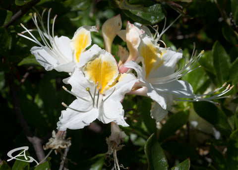
Descending for another mile, I marveled at the still-changing flora. As I passed over a ridge top, more Ponderosas, then dense patches of fragrant azaleas and madrone as the trail descended along the NW side. The terrain is impressively steep here and the valley is named Packsaddle Gulch. In the distance I could see a narrow band of lush green trees and realized this must the the North Fork Smith River. As I rounded the sharp bend in the trail at the end of the ridge, I stopped to look at the map and drink the last of my water.
The river was only maybe one to two miles away at this point, but the tingling in my legs I started my day with had not subsided. I was getting tired and had been stumbling a bit. Realizing I also hadn't told anyone where I was going, and had 3 miles to hike back, I admitted it was time to return. There will be more days soon, I hope, that I can return and get to that river and the California Pitcher Plants.
Sourdough Trail:
https://www.fs.usda.gov/recarea/rogue-siskiyou/recreation/hiking/recarea/?recid=69614&actid=50
Lemmingsworth Gulch Research Natural Area.
http://www.fsl.orst.edu/rna/sites/Lemmingsworth_Gulch.html
Anna Sereno
@anna.sereno.oregon
anna-sereno.smugmug.com